

Poster Estate Map - Greenslopes Curds Hill Estate Map 1925
Library Shop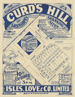
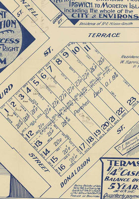
Poster print of estate map for Curds Hill Estate Greenslopes 1925. Land for sale being resubdivision 94 to 105 of subdivision 1 of subdivision 182 of 19 to 21 of subdivision B of portion 169. Parish of Bulimba. The estate was surveyed by: H.T. James Lithographers. Map includes conditions of purchase, and a brief description of the land, public transport and utilities available. Curd's Hill Greenslopes / Isles Love & Co., Auctioneers ; C.F. Bennett, Surveyor. Estate maps can give information about land subdivisions, including how the land was subdivided, when it was first auctioned, who the surveyors were and who sold the land. They are useful for investigating the history of urban land areas. They were also used as advertisements for land sales.
Print details
46cm x 59.4cm approx size. Prints are created using archival pigment inks on A2 size 200 gsm archival photo paper with a matte finish.
We leave a small white border of 10-15mm around the image area to protect it during shipping, to avoid fingerprints while being handled, and to allow for framing (prints do not come framed).
Prints will be carefully rolled and mailed in a protective tube.
Aside from a small selection in-store, all prints are print on demand. Please allow up to 48 hours for production