

Poster Estate Map - Princess Bridge, St Lucia, 1885
Library Shop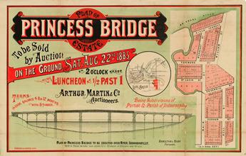
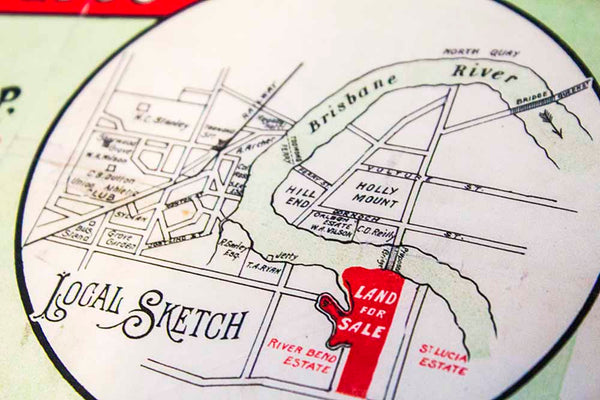
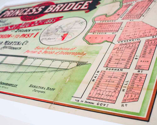
Estate map showing allotments for sale on 2nd August, 1885 by Arthur Martin & Co., auctioneers. The land was surveyed by Hamilton and Raff. The plan included a local sketch. The estate map also shows a plan of the proposed Princess Bridge that was to be erected across the Brisbane River at Indooroopilly.
Estate maps can give information about land subdivisions, including how the land was subdivided, when it was first auctioned, who the surveyors were and who sold the land. They are useful for investigating the history of urban land areas. They were also used as advertisements for land sales.
We leave a small white border of 10-15mm around the image area to protect it during shipping, to avoid fingerprints while being handled, and to allow for framing (prints do not come framed).
Prints will be carefully rolled and mailed in a protective tube.
Aside from a small selection in-store, all prints are print on demand. Please allow up to 48 hours for production.
ISBN: PODMA027
Format: Print Art
Dimension: 378mm X 594mm
Estate maps can give information about land subdivisions, including how the land was subdivided, when it was first auctioned, who the surveyors were and who sold the land. They are useful for investigating the history of urban land areas. They were also used as advertisements for land sales.
Print details
37cm x 59cm approx size. Prints are created using archival pigment inks on A2 size 200 gsm archival photo paper with a matte finish.We leave a small white border of 10-15mm around the image area to protect it during shipping, to avoid fingerprints while being handled, and to allow for framing (prints do not come framed).
Prints will be carefully rolled and mailed in a protective tube.
Aside from a small selection in-store, all prints are print on demand. Please allow up to 48 hours for production.
ISBN: PODMA027
Format: Print Art
Dimension: 378mm X 594mm